Rethinking New York City’s Resilience at the Neighborhood Scale
Resilient infrastructure can do more than manage stormwater. Done well, it can make communities safer and improve the places people use every day.
That idea has shaped Sherwood’s work with the New York City Housing Authority (NYCHA) as it expands its approach to stormwater flooding. NYCHA is one of New York City’s largest landowners, with 335 developments across all five boroughs. More than 360,000 residents live in NYCHA housing, with an average annual household income of about $25,000. Many of these communities have experienced decades of underinvestment, and many are exposed to risks of coastal flooding, inland flooding resulting from intense rainfall, or both.
From Sandy to Ida
After Superstorm Sandy devastated the region in 2012, NYCHA made major investments to protect properties from coastal flooding. The City was also studying another threat: what happens during a “cloudburst” event, when an enormous amount of rain falls in a very short period and overwhelms traditional sewer systems, resulting in rainfall-driven (i.e. pluvial) flooding.
In September 2021, Hurricane Ida brought that risk into sharp focus. More than seven inches of rain fell in a matter of hours, overwhelming drainage systems and causing severe flooding across the city. Modeled risks suddenly became a real-time reality. Ida also raised a practical question for NYCHA: across a portfolio this large, where could limited resources have the greatest impact?
Soon after Ida, NYCHA submitted an application to FEMA’s Building Resilient Infrastructure and Communities (BRIC) grant program for two Brooklyn developments: Breukelen Houses and Sheepshead Bay Houses, both supported by initial studies of flood risks. This funding application succeeded and enabled continued progress, building on a decade-long stormwater partnership with the NYC Department of Environmental Protection (NYC DEP), which includes pilot projects that the agencies developed at the site scale to address flooding from cloudburst events.
By the time NYCHA issued its Cloudburst RFP in 2023, flood mitigation was part of a broader investment in the communities themselves, prioritizing resident protection during extreme storms while upgrading the courtyards, walkways, and play spaces between the buildings.
Looking Beyond the Property Line
Cloudburst management was first pioneered in Copenhagen and adapted in New York, and recognizes that we cannot simply make underground pipes bigger. Streets, parks, plazas, and other open spaces can help move and temporarily store excess water until the drainage system catches up. Most of the time, these spaces serve residents as they always have, but during heavy rains, they take on an expanded role.
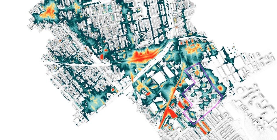
Water flows into and through the NYCHA developments from surrounding streets and neighborhoods, adding to the rain volume falling on site. This means we must look beyond individual property lines. At one of the two NYCHA developments, more than 2,000 acres of sewershed drain toward the campus; a single inch of rain sends roughly 29 million gallons to one downstream outfall. At that scale, the watershed is the site. Understanding why the property floods means understanding the entire drainage area it sits within, not just the immediate parcel.
Our team used 2D hydraulic modeling to understand how water moves across the site, its surrounding neighborhood, and the watershed. We analyze historic flood patterns and test rainfall scenarios and future climate projections to identify where water collects and where targeted interventions could have the greatest impact. We score every building by how often it floods and how severely, comparing existing infrastructure versus proposed, so performance targets are measurable before design begins. We then link that analysis to what residents experience on the ground: flooded building entrances, standing water on walkways, inaccessible routes, and outdoor spaces that become unsafe or unusable.
Working at this scale cuts both ways. At one of the developments, the proposed design will reduce flooding at the adjacent public park in a 25-year storm and keep travel lanes open on the bordering avenue—benefits delivered on land NYCHA doesn’t own. Interventions protect the surrounding neighborhood, not just the parcel that hosts them. In a dense city, water is always moving from one place to another. Addressing the problem effectively requires thinking at the neighborhood scale.
Making Infrastructure Work Harder
We communicate the design strategy through four basic actions: absorb, store, transfer, and convey. Each action engages as rainfall intensity increases: absorb handles the frequent, everyday storms at the surface; store takes over as rainfall exceeds what the ground can take; transfer engages when storage fills; and convey carries the most extreme events safely through the site. Together, they describe how water moves across a site and where we can intervene before it reaches a building or overwhelms the drainage system.
Absorb starts at the surface. Vegetated swales slow and absorb rainfall while directing excess water toward areas designed to handle it. Open spaces can also do double duty: sunken landscaping areas or grassy lawns can serve residents every day, then become a sponge to soak up water during light rainfall events.
Store creates places for excess water to go once absorption is maximized. Surface and underground storage hold water until the drainage system can catch up, reducing flood depths, prolonged ponding, and pressure on the existing pipe network. At several targeted locations, modeling shows these strategies can reduce flood depths up to 85% during a 10-year storm once implemented.
Transfer moves water away from vulnerable areas through targeted regrading and realigned drainage routes.
Convey addresses how water moves through and beyond the site as storms intensify, using adaptable systems that work alongside the existing pipe network.
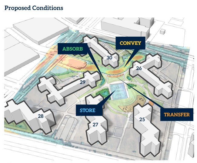
On Block 5N at Breukelen Houses, we chose to accommodate peak storm flows within designated open spaces through careful grading and landforming. This reduced reliance on large underground pipes or diverting flows into surrounding streets. The landscape directs water along controlled routes while protecting buildings and maintaining critical access, with paths, seating, and recreation integrated into the same ground.
That coordination also shaped the placement of underground storage. We shifted a proposed stormwater tank to preserve a mature tree with a trunk approximately five feet in diameter, maintaining the required storage capacity while protecting the established canopy. Both decisions show how flood protection can improve the landscape while preserving what residents already value.
We evaluate interventions by how often and how severely an area floods, how they perform across different storms, and their complexity and benefits for residents. Swales and targeted grading can address recurring problems with limited disruption, while berms and underground storage may be needed for greater protection. Together, these measures focus investment where it has the greatest impact while improving safety, landscapes, and everyday community spaces.
A Broader Definition of Resilience
NYCHA’s work after Sandy strengthened its capacity to address coastal flooding. The Cloudburst program adds another set of tools for properties exposed to extreme rainfall and expands how we think about resilience.
The definition widens in another direction too: the community gains strength alongside its stormwater infrastructure. Early in the design process, residents participate in workshops and vote on the preferred amenity program. Their lived experience of flooding validates the model. And stewardship agreements and resident hiring carry their role past design into construction and operations. A community that shapes its own infrastructure, understands how it works, and has a stake in maintaining it is itself more resilient than one that simply receives amenity upgrades.
This offers a valuable lesson for other cities. Regulations give us a starting point, but we can look beyond individual parcels and minimum requirements to understand how water moves through a neighborhood. We can plan for the storms communities face today as well as those projected for the future. And when major public investment is required, we can ensure it delivers the greatest overall benefit, measured in community outcomes as well as gallons.
Reducing flood risk remains the job we were brought in to do. But the results can extend well beyond the storm: safer routes through the community, better outdoor spaces, healthier landscapes, and greater protection for residents.
Those are benefits people can experience every day, whether it’s raining or not.